Labels

Aberdeenshire (21) Angus (4) antiquities (87) Argyll and Bute (35) Arran (7) art (37) birds (231) bridge (9) Caithness (12) Carmarthenshire (5) castle (165) Ceredigion (9) Channel Islands (13) Cheshire West and Cheshire (1) City and County of Swansea (1) City of Bristol (2) City of Edinburgh (4) Conwy (8) Cornwall (74) County Antrim (19) County Down (23) County Durham (3) County Londonderry (4) Cumbria (19) Denbighshire (2) Devon (48) diving (7) Dorset (18) Dumfries and Galloway (22) Dundee City (2) East Lothian (6) East Sussex (16) East Yorkshire (6) English Riviera (3) Essex (17) Fife (19) Flintshire (1) food (13) fossils (14) gardens (28) Ghosts (35) Glamorgan (1) Gower (7) Guernsey (4) Gwent (1) Gwynedd (19) Hampshire (13) Highland (72) Inner Hebrides (42) Inverclyde (5) Islay (8) Isle of Anglesey (14) Isle Of Man (7) Isle Of Wight (10) Isles of Scilly (3) Jersey (7) Kent (22) Lancashire (8) Lewis and Harris (7) lighthouse (62) Lincolnshire (8) Merseyside (8) Mid Glamorgan (1) mining (23) Moray (10) Mull (8) Norfolk (21) North Ayrshire (13) North Yorkshire (12) Northern Ireland (45) Northumberland (17) Orkney (10) Outer Hebrides (14) Pembrokeshire (27) pubs (47) Ross and Cromarty (20) Scotland (300) Scottish Borders (3) Shetland (14) shipwrecks (42) Skye (12) smuggling (48) Somerset (9) South Ayrshire (6) South Glamorgan (5) South Gloucestershire (1) Suffolk (18) surfing (83) Sutherland (16) Tyne and Wear (10) Wales (93) wartime (75) webcams (232) West Dunbartonshire (3) West Glamorgan (9) West Sussex (9)

Thursday 30 August 2012

STROMEFERRY

A small, idyllic settlement on the west coast of Scotland seems an unlikely venue for a riot, but this is exactly what happened one Sunday in 1883 when over 200 fishermen, enraged by the Highland Railway Company's disrespectful attitude towards the Sabbath in continuing to run a Sunday train service, converged on the railway terminus to prevent the unloading of fish bound for London. The local constabulary proved unequal to the task of quelling the riot judging by newspaper reports of the time: "...the chief constable of Rosshire arrived from Dingwall with six policemen - all the force he could muster"...."Sticks were freely used by the fishermen, and the chief constable himself and two of his men got some hard knocks". Further unrest ensued at a later date, this time with the women weighing in: "...the women filled their aprons with stones, with which they pelted the constables so vigorously that they had to retreat".* 10 men ended up in prison and the subject was debated in the House of Commons, which maintained that there was no law preventing Sunday traffic in Scotland.

Thankfully, such events are but a distant memory in this village on the south shore of Loch Carron. The railway still operates, unimpeded by angry locals, although the ferry across the loch to North Strome which gave rise to the name of the village ceased operating in 1970. Earlier this year a temporary ferry service had to be hastily rustled up after the A890 road was blocked by a series of rockfalls. Without this temporary service, a 140-mile detour via Inverness on the east coast would have been the order of the day! The village is surrounded by woodland, and there is a pleasant circular route through the woods which takes in lovely views of the loch and mountains.

* From a report by the Edinburgh correspondent of the Otago Daily Times.

Map of the area.

Stromeferry ferry 2012 - geograph.org.uk - 2808301. Photo by Roy Tait, via Wikimedia Commons.


Tuesday 28 August 2012

ATTADALE

Like Poolewe further to the north, Attadale has a treat in store for garden lovers, in the form of the fabulous Attadale Gardens, a colourful 20 acres of rhododendrons, Himalayan primula and other exotic plants set in a beautiful location with lovely views across the loch, with the peaks of Skye visible in the distance.  The gardens, which also feature a sculpture collection, form part of a 30,000 acre estate belonging originally to the Clan Matheson, with as its focal point a house built in 1755. Fans of the TV series Hamish Macbeth may experience a deja vu moment when visiting the house, as it was used in the series. There is not a lot more to Attadale, but it does have a tiny railway station, being on the Inverness-Kyle of Lochalsh railway line.

Map of the area.


File:Attadale House and Gardens by Loch Carron - geograph.org.uk - 68846.jpg
Attadale House and Gardens by Loch Carron - geograph.org.uk - 68846. Photo by David Crocker, via Wikimedia Commons.


Sunday 26 August 2012

LOCHCARRON

One of the many legends and mysteries around the coast of Scotland concerns a wise woman who lived at the head of Loch Carron. Such were her powers of healing that a person only had to present her with a piece of clothing belonging to the sick individual, which she would work her magic on, resulting in a miraculous recovery. However, there was an unfortunate side effect for the woman, who herself became very ill for several days afterwards. People came from miles around to avail themselves of her services.

The village of Lochcarron, which lies strung out on the shores of the loch, started out as a much smaller settlement known as Janetown, but it grew dramatically in size due to the arrival of people displaced by the Highland Clearances. The area to the north of the village, known as Kirkton, is the location of a small, whitewash church built in 1883, and there is also a ruined church and graveyard dating from 1751. Walking is a favourite activity around here, as well as wildlife watching, with plenty of opportunities to combine the two. Otters, pine martens and deer are just some of the creatures the patient walker might encounter.


Map
of the area.

Lochcarron - geograph.org.uk - 8142. Photo by Anne Burgess, via Wikimedia Commons.


Friday 24 August 2012

APPLECROSS

Applecross, which lies on a peninsula bearing the same name, has as its origin a monastery which was established by the Irish monk Maelrubha in 673. The area around the monastery was made into a sanctuary, hence the gaelic name of the village, a'Chomraich. The village was a good choice for a sanctuary, with its location on a sheltered bay, surrounded by wooded hills. You know you are in for something special in Applecross on the approach to the village, which is reached via Bealach Na Ba ('Pass of the Cattle'), the highest mountain pass in Britain, a highlight for anyone undertaking the North Coast 500 scenic route. The journey over the pass is rewarded with spectacular views of Raasay and Skye as well as the mountains of the mainland.

The weather can be savage in this part of Scotland but shelter from the worst that the elements can throw at the visitor can be found in a couple of cafes, one forming part of a Walled Garden, as well as the acclaimed Applecross Inn, renowned for its food, and also offering accommodation. There is a campsite for hardier types, while those wanting to brave the great outdoors will find sea kayaking, mountain walking and other outdoor activities.  Just outside the village is the Applecross Heritage Centre, which keeps a collection of artefacts and archives from the local area.


Map of the area.


Wednesday 22 August 2012

SHIELDAIG

The topography around Shieldaig follows a by now familiar pattern along this stretch of coast, with the village lying on the shores of a loch by the same name, with a small island just offshore, also bearing the same name. Loch Shieldaig lies between Loch Torridon and Upper Loch Torridon, and the village, comprising mainly white houses, is strung out along the shore, with the loch in front and the mountains behind. The village is relatively new, established in 1800 by the Admiralty, who lured families to the location by offering grants for housing and boat-building. However, there was an ulterior motive behind the Admiralty's largesse: to build up a supply of suitably experienced seamen for service during the Napoleonic Wars. In the early 21st century, the spectacular landscape around Shieldaig was threatened with a proposed hydro electric scheme, but the Scottish Executive sensibly rejected the scheme on the grounds of potential damage to the environment and the local communities.

Shieldaig Island is run by the National Trust for Scotland, and is covered with Scot's Pine. The island is a sanctuary for a variety of birds including sea birds, long-eared owls and kestrels, and can be visited but landing is by permission only. The village is the departure point for sea tours by catamaran from April to October offering the chance to see a wide range of wildlife of the feathered variety as well as seals, dolphins, porpoises and otters. For those wanting to stay overnight - and who wouldn't? - accommodation in the village ranges from rooms in an award-winning hotel to a campsite.

Map of the area.


Monday 20 August 2012

TORRIDON

The village of Torridon within the area of the same name is a tiny settlement close up, but from a distance it appears positively minute set against the enormous backdrop of the Liathach mountain. Beinn Alligin and Beinn Dearg are two other peaks contributing to the dramatic scenery surrounding the village, with the mountains rising up to 3,500 feet above the lochs. Walking is a favourite pastime here, and the Countryside Centre, run by the National Trust for Scotland, has plenty of information on walks in the area. The estate where the centre is located is also home to a Deer Museum, and herds of red deer and Highland cattle can be viewed nearby, while the loch is frequented by otters and seals. Birdwatchers should keep an eye out for sea eagles and golden eagles.

Life in Torridon has not always been so idyllic. The area suffered particularly badly during the Highland Clearances at the hands of one Colonel McBarnet who, not content with having exploited workers at his plantation in the West Indies, moved on to kicking out the local populace of Torridon, forcing them to move to inferior land at the head of the loch. However, better times came with the sale of the estate to Duncan Darroch, who was responsible for introducing the deer to the area and gave evicted tenants their land back. There is a memorial stone by the roadside erected by Darroch's widow in 1921 with an inscription which makes reference to the "devotion and affection shown by one hundred men on the estate of Torridon".

Map of the area.

View northwest from below Carn Dhonnachadh - geograph.org.uk - 694215. Photo by Nigel Brown, via Wikimedia Commons.


Friday 17 August 2012

GAIRLOCH

Glancing through the news archives for Gairloch, a headline from 1961 caught my attention: ""Terrorists" beaten back at Gairloch". Intrigued that such a dramatic event should have taken place in an idyllic spot on the west coast of Scotland, I clicked through to the article, but it turned out to be an exercise involving nearly 500 officer cadets from Sandhurst. The exercise had the "terrorists" landing on the shore with the aim of inciting the locals to riot, while being dealt with by troops aided by army helicopters. The exercise must have toughened the cadets up quite considerably, as the weather was atrocious and they were forced to spend much of their time out in the open. No doubt the proceedings provided a considerable amount of excitement for the residents of this sleepy community.

Loch Gairloch is one of a series of bays and sea lochs along this stretch of coast, with Gairloch itself consisting of several communities strung out along the shores of Strath Bay. Settlement here dates back at least to the Iron Age, and the remains of a fort from that time still occupy a headland near the Golf Club. Later, the Vikings arrived and used the loch as a haven. The area is now owned by the Mackenzies, who were granted the land by King James IV in 1494. Gairloch used to have an important cod fishing industry, with a large proportion of the catch being dried at Badachro on the south side of the loch for export to Spain. Now there are only a few fishermen left, while some boat owners have turned their attention to tourism, with wildlife viewing and fishing trips on offer. Gairloch has its own heritage museum, where one of the exhibits is a Pictish stone with a salmon carving, found here in 1880.

Map of the area.


Gairloch, Strath Bay - geograph.org.uk - 2229942. Photo by Ken Bagnall, via Wikimedia Commons.

Wednesday 15 August 2012

POOLEWE

The sea loch known as Loch Ewe has something in common with Gruinard Bay to the north, in that it has an island in the middle of it, the Isle of Ewe. The views across the loch are enhanced by the dramatic backdrop of the mountains just inland. The River Ewe flows into the loch at Poolewe, an attractive village with neat little whitewash houses at the head of the loch. The main attraction hereabouts is the spectacular Inverewe Garden. Visitors to the garden could be forgiven for thinking they had been teleported to Cornwall, as the plants here have more in common with the gardens of the south west than anything normally found in Scotland. It is thanks to the North Atlantic Drift that such subtropical beauties as rhododendrons, azaleas and exotic border plants are able to thrive here. Naturally, summer is the most colourful time to visit the garden, but autumn brings its own reward, when the treasures on view include Agapanthus and Watsonias, natives of South Africa. The wildlife in the area around Poolewe includes seals, otters, pine martens and sea eagles.

Map of the area.

Inverewe Garden in early summer


Monday 13 August 2012

GRUINARD BAY

Gruinard Bay is a north-facing bay with the small Gruinard Island in the middle. There are several beaches on the east side of the bay, at Mungasdale, at the mouth of the Gruinard River and at Little Gruinard. Along this stretch of the bay is Gruinard House, with a lovely garden which is occasionally open to the public on certain dates in aid of charity. Further round towards the west is the small settlement of Laide, notable for its ancient chapel and cemetery overlooking a small sandy beach. The chapel is believed to date originally from medieval times, with restoration work carried out in 1713. There may have been an even earlier place of worship on the site built by St Columba. Further round still is Mellon Udrigle, from where a path leads to the fabulous Camas a'Charaig beach, an expanse of white sand backed by dunes offering spectacular views of the mountains to the north, including the mighty Suilven near Lochinver.

Map of the area.


Gruinard Beach


Sunday 12 August 2012

BARRA AND VATERSAY

Barra can be reached by ferry from Eriskay as well as from Oban on the mainland. Such is the appeal of this tiny island, with its green machair dotted with flowers in springtime and its beautiful, empty beaches, that it has been nicknamed "Barradise". The island's main road loops round in a circle, providing an ideal thoroughfare for cyclists. In my blog post about Eriskay, I mentioned that Eriskay was where the events took place which provided the inspiration for the Whisky Galore book and film. The film was shot in Barra (under the name "Tight Little Island" in the US). The main settlement on Barra is the village of Castlebay, which as its name suggests, has a castle in its bay. This is the medieval Kisimul Castle, accessible to visitors via a ferry, and offering fine views of the bay. The castle was bought in 1937 by the chief of the Clan MacNeil, who has since leased it to Historic Scotland. Next week there is an international gathering of the clan at the castle.

Vatersay is another island, linked to Barra by a causeway which was completed in 1991. The island is a magnet for lovers of ancient remains, having an Iron Age Broch (at Dun a' Chaolais) and a Bronze Age cemetery (at Treasabhaig) to name but two sites. Nature lovers will find otters, seals and herons, along with sparkling white beaches. There is a monument on the island commemorating a shipwreck which occurred in 1853. The ship, Annie Jane, was on its way from Liverpool to Montreal, but succumbed to a storm off Vatersay, where, in spite of the best efforts of the local people, only a few survivors were rescued. Another reminder of past tragedy is the remains of the JX273 Catalina flying boat, which crashed here during a training flight from Oban.

Map of the islands.

View south from Heaval. Photo by Chris McLean, via Wikimedia Commons.


Thursday 9 August 2012

ERISKAY

Eriskay secured its place in history in 1745 when Bonnie Prince Charlie arrived there with a handful of followers, intent on starting an uprising in support of his father James Stewart, the exiled King of Great Britain. It is said that a reminder of that event lives on in the form of the sea bindweed which grows on the island. This plant is not native to the Hebrides, and the story goes that the Prince accidentally let some seeds drop from a handkerchief after landing on the island. Another event which the island is famous for, and which was the inspiration for a book and a film, was the story of a shipwreck which was raided by the islanders for its consignment of 24,000 cases of whisky. The ship was the SS Politician, which sank off the island in 1941 and the book was Whisky Galore by Compton Mackenzie, which came out in 1947, followed by an Ealing comedy film two years later. The film was actually shot on the nearby island of Barra. It has since transpired that it was not only whisky that disappeared from the shipwreck, but also a substantial sum of money. The SS Politician was carrying eight cases of currency bound for the West Indies and the United States.

Eriskay is a mere 6 square miles, with around 100 inhabitants. There is just one shop, which was started by the local people as a co-operative after the island's shop and post office closed in the late 1970s. Being the only shop on the island, it offers a wide range of goods and doubles as a Post Office. The island as a whole was taken over by the residents in 2006 in a community buy-out. Eriskay can be reached from South Uist by a causeway, from where a narrow, gently undulating road weaves through the emerald green machair, which in spring is thick with daisies and marsh marigolds. In summer there are boat trips with a good chance of seeing the bottle nosed dolphins which visit the waters off the island at this time of year.

Map of the island.

Eriskay. Photo by Kenny Davidson, via Wikimedia Commons.


Tuesday 7 August 2012

SOUTH UIST

South Uist is an isle of two halves: the east is mountainous with numerous indentations and sea lochs, while the west coast consists of an almost continuous beach backed by dunes over 20 miles long. The flatness of the west coast makes it vulnerable to the elements, as was the case in 2005 when a devastating storm with 150 mph winds caused extensive damage to buildings and killed several people. In a terrifying vision of the effects of climate change, it has been predicted that sea levels around South Uist will rise by 37cm by 2080, making the future of the west coast precarious to say the least. Recognising the urgent need to provide protection for this coastline, and frustrated by the inaction of the local authorities, the locals have taken matters into their own hands, using tyres and fishing nets to build a seawall. The lochs of the east coast are rich in wildlife, such as the mute swans of Loch Bee. The freshwater Loch Druidibeg is a nature reserve with a large colony of greylag geese as well as a number of corncrakes.

South Uist, unlike other Hebridean islands, is Catholic, and probably the most prominent sign of this is the granite sculpture of the Virgin Mary known as "Our Lady of the Isles", erected in 1957. The statue was commissioned by a local parish priest in response to proposals to create a large missile test range on the island. The priest was one of the main opponents to the proposals, but his protestations fell on deaf ears and the test range went ahead as planned, overlooked by the statue. The island's leisure activities include an unusual example of a 'lost' golf course. Askernish Golf Course was first laid out in 1891 by Old Tom Morris, but was abandoned in the 1920s. However, the course was restored and reopened in 2008 with a new clubhouse. Fans of archaeology should head to the Kildonan Museum, where the archaeological finds include the Clanranald Armorial Stone, carved with the Clanranald Arms. The Jacobite heroine Flora MacDonald, famous for her assistance to Bonnie Prince Charlie while living on Benbecula, was born on South Uist, and there is a monument marking her birthplace at Milton. The main settlement on the island is Lochboisdale, from where there is a ferry service to Oban.

Map of the island.

Beach, South Uist - geograph.org.uk - 601902. Photo by F Leask, via Wikimedia Commons.


Sunday 5 August 2012

BENBECULA

Benbecula is sandwiched between the islands of North and South Uist, and is reachable from either of them by road. There is also an airport, and those who arrive by air may be interested to known that it started off as a military airfield, built during World War II. Later, during the Cold War, the airfield was used as the control centre for the Hebrides rocket range. Nowadays there is an army base which is one of the main employers on the island, and which services the South Uist missile test range. The island has a similar topography to its neighbours, with numerous sea lochs dotted among the land.

The origin of Benbecula's gaelic name, Beinn na Faoghla, is slightly puzzling, since it means "mountain of the fords", however there are no mountains on Benbecula, whose highest point is 124 metres. The west side of the island is a mixture of machair (low grassy plain) and white beaches with sand dunes. In the south-west of the island lie the remains of the 14th century Borve Castle which was occupied by the MacDonalds of Benbecula until the early 17th century, while at the northern end lie the Gramsdale Standing Stones.  The main settlement on the island is Balivanich, whose name, meaning "town of the monks", harks back to a monastery established in the 6th century.

Map of the island.

Benbecula Beach 2. Photo by Paul Birrell, via Wikimedia Commons.


Saturday 4 August 2012

NORTH UIST

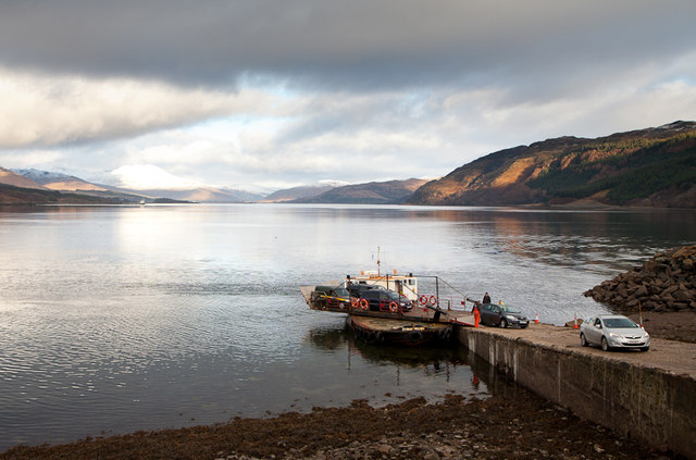
Looking a a map of the Outer Hebrides, they have the appearance of one of those dinosaur skeletons one sees at natural history museums, with Lewis and Harris forming the skull and the smaller islands further south forming the spine (at least that's how it looks to me - maybe I have an over-active imagination). North Uist is the top part of the "spine", and it, and the other islands further south, have the appearance of shattered bones, so great is the number of tiny islands strewn off the 'mainland' of the bigger islands. The main town on North Uist is Lochmaddy, which is served by ferries to Uig on Skye and Tarbert. The town's attractions include the Taigh Chearsabhagh arts centre. The numerous freshwater lochs dotted around the eastern part of the island are prized for sea trout and salmon fishing, which can be arranged via the main hotel in Lochmaddy. They are also perfect for sea kayaking. The west coast is a haven for birdwatchers, and is home to the Balranald RSPB reserve. Beachlovers will not be disappointed either, as there are a number of beautiful beaches on the island.

There are a number of prehistoric sites on North Uist. Near Lochmaddy is a stone circle called Na Fir Bhreige, or "The False Men", so named because according to legend they are a group of men who deserted their wives and were turned to stone for their treachery. There are more standing stones at Pobull Fhinn, as well as a chambered cairn at Barpa Langass. The island is also home to the earliest crannog (waterside dwelling) in Scotland, at Eilean Domhnuill. Just off the west coast is the Isle of Vallay, which can be reached on foot at low tide via a wide strand. The island is uninhabited, but there were once around 60 people living there, and the island is known for its forbidding deserted, semi-ruined mansion.

Webcam view towards the west from Carinish.

Map of the island.

Traigh Stir, North Uist - geograph.org.uk - 7073. Photo by Sue Jackson, via Wikimedia Commons.


Wednesday 1 August 2012

BERNERAY

Berneray is a small island in the Sound of Harris, just off the island of North Uist, and linked to it by a causeway. It can also be reached by ferry from Leverburgh in the Isle of Harris. A much earlier ferry service, operating from Bays Loch, was started up in the early 18th century by the then owners of the island, the MacLeods of Harris. A few years earlier in 1697 a village on the island called Siabaidh met tragedy when it was consumed by sand during a storm. Kelp was once the mainstay of the island's economy, but after that declined it became a major grower of potatoes. Like so many other small Scottish islands, Berneray's population has declined steadily over the years, but the opening of the causeway by Prince Charles in 1999 marked a new era of connectivity for the island, along with the harbour which was built around the same time for the Leverburgh ferry, all of which has made life a little easier for the remaining inhabitants. For visitors, there is a vast, sparkling beach on the west side of the island, a small selection of places to stay including a youth hostel, and a Visitor Information Centre at The Nurse's Cottage, home to the island's Historical Society. Each year in July the island holds its Berneray Week, which includes events such as races, an RNLI Open Day and Gaelic taster classes and song classes.

Map of the island.

Berneray Machair. Photo by Richard Webb, via Wikimedia Commons.