Labels

Aberdeenshire (21) Angus (4) antiquities (87) Argyll and Bute (35) Arran (7) art (37) birds (231) bridge (9) Caithness (12) Carmarthenshire (5) castle (165) Ceredigion (9) Channel Islands (13) Cheshire West and Cheshire (1) City and County of Swansea (1) City of Bristol (2) City of Edinburgh (4) Conwy (8) Cornwall (74) County Antrim (19) County Down (23) County Durham (3) County Londonderry (4) Cumbria (19) Denbighshire (2) Devon (48) diving (7) Dorset (18) Dumfries and Galloway (22) Dundee City (2) East Lothian (6) East Sussex (16) East Yorkshire (6) English Riviera (3) Essex (17) Fife (19) Flintshire (1) food (13) fossils (14) gardens (28) Ghosts (35) Glamorgan (1) Gower (7) Guernsey (4) Gwent (1) Gwynedd (19) Hampshire (13) Highland (72) Inner Hebrides (42) Inverclyde (5) Islay (8) Isle of Anglesey (14) Isle Of Man (7) Isle Of Wight (10) Isles of Scilly (3) Jersey (7) Kent (22) Lancashire (8) Lewis and Harris (7) lighthouse (62) Lincolnshire (8) Merseyside (8) Mid Glamorgan (1) mining (23) Moray (10) Mull (8) Norfolk (21) North Ayrshire (13) North Yorkshire (12) Northern Ireland (45) Northumberland (17) Orkney (10) Outer Hebrides (14) Pembrokeshire (27) pubs (47) Ross and Cromarty (20) Scotland (300) Scottish Borders (3) Shetland (14) shipwrecks (42) Skye (12) smuggling (48) Somerset (9) South Ayrshire (6) South Glamorgan (5) South Gloucestershire (1) Suffolk (18) surfing (83) Sutherland (16) Tyne and Wear (10) Wales (93) wartime (75) webcams (232) West Dunbartonshire (3) West Glamorgan (9) West Sussex (9)

Friday 27 November 2015

WOODY BAY AND HEDDON'S MOUTH


On one of our weekends in Lynmouth, my husband and I went on the shortest steam train journey we have ever made at Woody Bay – and we have made a few.  The station here is the departure point for the Lynton and Barnstaple Railway, originally opened in 1898 and closed in 1935.  Now there is a project underway to rebuild this narrow gauge railway.  The day we went we were only able to go a couple of miles westwards along the track and back again, but the plan is to eventually extend the line all the way to Barnstaple.  Woody Bay itself is reached via a steep track wending its way through dense woodland, starting from a nearby car park.  Obviously, with such a challenging approach, the sand and shingle beach is completely as nature intended, with no facilities, so pack a picnic. 

From Woody Bay, a two and a half mile stretch of coast path leads to Heddon’s Mouth, a cove at the mouth of the River Heddon, which flows down to the sea through a steep valley with scree-covered sides.  The coastal walk takes in the site of a Roman fort built to repel the Welsh. The cove can also be reached via a path from a car park at Hunter’s Inn.  The author of the 19th century novel Lorna Doone, R. D. Blackmore, is heavily associated with these parts, and Heddon’s Mouth features in two of his other works, Clara Vaughan and Maid of Sker.

Map of the area. 

File:Coastal path near Heddon's mouth - geograph.org.uk - 691769.jpg
Coastal path  near Heddon's Mouth - geograph.org.uk - 691769. Photo by Dave Croker, via Wikimedia Commons.

Friday 20 November 2015

LYNMOUTH


I have visited the small North Devon seaside town of Lynmouth several times, but one visit stands out in my memory.  This was the first weekend after the terror attacks of 9/11, and like most people at that time I was suffering from a deep feeling of anxiety and insecurity – a feeling sadly reinforced after recent events in Paris.  I remember being struck by what a lovely, peaceful place Lynmouth was to be after such a terrible event, so much so that it was hard to drag myself away.  This feeling was helped by Lynmouth’s geographical location at the bottom of a steep wooded valley, which gives the impression of being almost cut off from the world and its problems.  

Unfortunately, there is a downside to the geography of Lynmouth and the surrounding area.  The steepness of the terrain, combined with the fact that two rivers, the East and West Lyn rivers, converge in the town,  makes Lynmouth vulnerable to flooding.  This was tragically demonstrated on the night of 15-16 August 1952 when heavy rain caused the rivers to swell, sending a wall of water cascading down through the town, made even more dangerous by the boulders being swept along with it.  34 people lost their lives on that dreadful night, and over 100 buildings were destroyed.  There is a permanent exhibition on the disaster down by the harbourside in the Flood Memorial Hall, and there is archive footage on the British Pathe website about the disaster and subsequent rebuilding efforts.  Suspicions have been voiced that the flooding was caused by rainmaking experiments by the RAF and a team of scientists, but this has been dismissed by experts.  More recently, Lynmouth was one of many locations on the British coast affected by flooding in 2014, but earlier this year it was announced that the town would get a grant for flood defences.

Lynmouth's harbour is surrounded by a small cluster of shops, pubs and restaurants, with the picturesque harbourside inn The Rising Sun forming a focal point.    One of the main attractions in the town is the Cliff Railway, which links Lynmouth to its neighbour at the top of the cliff, Lynton.  This makes a pleasant alternative to walking up the steep hill for the carless.  Lynmouth is great for walking, with a lovely trail leading from the town up to Watersmeet, taking in a National Trust tea room.  Another wooded valley which can be explored by visitors is the Glen Lyn Gorge.  There is an entrance fee for this one, but in return for this there are a range of interesting features on view such as the chance to learn about renewable energy, water wheels, water cannons and hydroelectric turbines, while visitors to the gorge can view the 1952 flood level reached there.  Just outside Lynton, the Valley of the Rocks is a lovely, rugged spot for wandering around on foot, taking in part of the coastal path.  The rock faces are dotted with cute goats going about their business and observing the walkers.  

Map of the area. 

Webcam view of East Lyn river.

The harbourside


Thursday 12 November 2015

PORLOCK


There are actually two Porlocks.  There is the village of Porlock a short distance from the shoreline, and then there is Porlock Weir, a proper little working harbour nestling at the foot of Exmoor.  Porlock village has some interesting historical features, most notably in the parish church, a 13th century church dedicated to St Dubricius, which houses the tomb of John Harrington, who fought alongside Henry V in France.  The Dovery Manor Museum, which occupies a medieval manorial dower house dating from 1450, has local artefacts, displays and pictures as well as a physic garden with plants grown for medicinal and culinary use.  The village and surrounding area was frequented by the poet Coleridge, who lived nearby and who went walking in the area with Wordsworth.  Their friend Robert Southey wrote a poem called “Porlock” in 1798.  The poem describes the “verdant vale so fair to sight”, “lofty hills which fern and furze imbrown” and “waters that roll musically down thy woody glens” – a pretty accurate depiction of Porlock’s picturesque surrounds.  There is a walking trail named after Coleridge, the Coleridge Way, which ends in Porlock outside the Visitor Centre.

One of the things Porlock is particularly well known for, particularly among cyclists, is the legendary Porlock Hill, which forms part of the A39 heading west towards Lynton.  According to the RCUK cycling website, the hill’s vital statistics are: length 2.5Km, elevation 304m, average gradient 12% and maximum gradient 25%.  However, for those who find such gradients too much of a challenge there is an alternative route in the form of the Porlock Toll Road, which is longer but only with an average 5% gradient.  The Toll Road, which is used by cars and walkers as well as cyclists, also offers fabulous views.

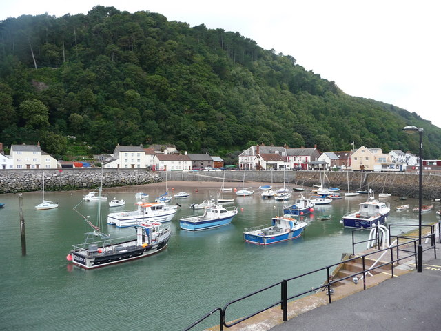
Porlock Weir with its 15th century harbour was once a busy port thanks to its role in handling coal imports from Wales.  Now it is frequented by yachts and fishing boats, and is a popular tourist spot due to its beautiful setting and its handful of shops, its harbourside inn and fine dining hotel.  It was the Saxons who originally developed a port and fishery here and it was also they who repelled two major attacks by the Danes in 886 and again in 918.  In 1052 a further attack came, this time at the hands of Harold (he of the Battle of Hastings), who had come across from Ireland.  The many quaint buildings in the vicinity of the harbour include the 17th century Gibraltar Cottages.  The waterside location of the cottages proved to be their downfall in 1910 when a tidal wave event flooded them.  On Porlock Beach the remains of a submerged forest can be seen at low tide, and in 1999 the bones of an aurochs (wild ox) were discovered on the beach.  A 2-mile walk from Porlock Weir leads to Culbone, where England’s smallest church, St Beuno’s, can be found.  You may as well leave the car behind for this one, because the church is only accessible on foot.

Live streaming webcam view of Porlock Weir.

Map of the area. 

File:Porlock Weir Public House - geograph.org.uk - 520858.jpg
Porlock Weir Public House - geograph.org.uk - 520858. Photo by Geoff Lees, via Wikimedia Commons.


Tuesday 3 November 2015

MINEHEAD


Minehead has all the trappings of a popular family resort, with a mile of sandy beach, amusements and a promenade, as well as a long-standing Butlins holiday camp (more recently elevated to ‘resort’ status).  However, there are also more quaint parts of town to explore such as Quay Town dating from the 11th century.  The harbour here was once busy with ships and there was a thriving trade with America.  In 1901 a pier was built to accommodate the White Funnel steamers, but the pier had to be demolished during the Second World War in order to give better visibility for the gun emplacements stationed there.  Another older part of town is Higher Town, built around the 14th century St Michael’s Church.  Lower Town, where the main shopping centre is now, was largely destroyed by a major fire at the end of the 18th century, and had to be rebuilt.

One of the big attractions nowadays is the West Somerset Railway, which starts in Minehead and follows the coast for a while before turning inland towards Bishops Lydeard near Taunton.  There are boat trips from the harbour in summer, including trips on the MV Balmoral, a survivor from the White Funnel line.  Each year around May Day there is a festival which is similar to the better-known Obby Oss festival in Padstow.  In Minehead’s version the Sailors’ Hobby Horse, decorated with ribbons, dances through the streets to the accompaniment of a drum.  Traditionally the ritual was intended as a way of fending off marauding Vikings.  Minehead’s main literary claim to fame is that it was the birthplace of Arthur C Clarke, the science fiction writer.   

Looking to the north-west of Minehead, the eye is drawn to a steep, wooded elevation.  As well as being the first (or last) part of the South West Coast Path – a baptism of fire for those starting the path at this end, as they are carried up a steep incline towards Selworthy Beacon – this wooded mound marks the start of what is one of my favourite stretches of coast in Britain, a glorious roller coaster of tall dramatic cliffs and deep wooded valleys stretching from West Somerset along the North Devon coast - of which more anon.  

For a list of events in Minehead, follow this link

Live streaming webcam view of the harbour.

Map of the area.

File:Minehead , Minehead Harbour - geograph.org.uk - 1212471.jpg
Minehead, Minehead Harbour - geograph.org.uk - 1212471. Photo by Lewis Clarke, via Wikimedia Commons.